
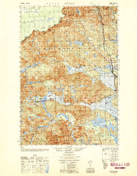
1950 Map of Attean
USGS Topo · Published 1950About this map
The Canadian Pacific railway cuts a distinct path through this Somerset County borderland, connecting the remote settlements of Holeb and Jackman Station. This 1950 update of 1940s aerial photography captures a landscape of intense logging and water-based transit, centered on the sprawling waters of Attean Pond and Wood Pond. The presence of the Stetson Sch and Boston Ranch indicates established, albeit isolated, pockets of activity within the township structure of Dennistown and Attean. To the north and west, the international boundary between Quebec and Maine follows the height of land, where Slidedown Mt and Bald Mountain overlook the Liniere River and Sandy Stream. The map reveals a complex network of interior waterways, from the narrow Spencer Rips to the expansive Hog Island, which were essential for timber movement and regional access before the expansion of modern road systems.
Find a feature on this map
68 named features on this map. Tap any name to fly to it.
Don’t see what you’re looking for? This feature index may not catch every label — zoom into the map to look around manually.
Map Details
Editions of this 1950 Attean Map
2 editions found
Other maps of this area

1922 · Long Pond
USGS Topo · 1:62,500

1923 · Attean
USGS Topo · 1:62,500

1924 · Long Pond
USGS Topo · 1:62,500

1925 · Pierce Pond
USGS Topo · 1:48,000

1925 · Attean
USGS Topo · 1:62,500

1927 · Sandy Bay
USGS Topo · 1:48,000

1927 · Pierce Pond
USGS Topo · 1:62,500

1928 · Chain Lakes
USGS Topo · 1:48,000

1928 · Skinner
USGS Topo · 1:48,000

1928 · Spencer
USGS Topo · 1:48,000