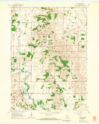
1961 Map of Attica
USGS Topo · Published 1964About this map
The Sugar River meanders through the western portion of this 1961 landscape, defining the rural character of the border between Dane and Green counties. The map highlights a mid-century agricultural region where small crossroads and family legacies are preserved through landmarks like Jug Prairie Cem and Oak Grove Sch. Near the village of Brooklyn, the Chicago and North Western railroad cuts across the northeastern corner, linking the local farming economy to larger regional markets.
Find a feature on this map
26 named features on this map. Tap any name to fly to it.
Don’t see what you’re looking for? This feature index may not catch every label — zoom into the map to look around manually.
Map Details
Editions of this 1961 Attica Map
2 editions found
Other maps of this area

1889 · Evansville
USGS Topo · 1:62,500

1893 · Brodhead
USGS Topo · 1:62,500

1894 · Evansville
USGS Topo · 1:62,500

1906 · Evansville
USGS Topo · 1:62,500

1920 · Monroe
USGS Topo · 1:62,500

1922 · Monroe
USGS Topo · 1:62,500

1923 · New Glarus
USGS Topo · 1:62,500

1954 · Rockford
USGS Topo · 1:250,000

1955 · Rockford
USGS Topo · 1:250,000

1958 · Rockford
USGS Topo · 1:250,000