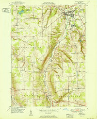
1951 Map of Attica
USGS Topo · Published 1951About this map
Attica sits at a critical junction of rail and river in Wyoming County, where the Erie RR and the Arcade and Attica RR meet along the banks of Tonawanda Creek. This 1949 survey captures the village's footprint just years after the end of World War II, showing its central sewage disposal and the imposing structure of the Attica State Prison. Outside the village center, the landscape is defined by the steep terrain of Poland Hill and Cobble Hill, separated by the Johnson Valley. Small rural hamlets and agricultural junctions like Varysburg, East Bennington, and Dutch Flats remain connected by a network of numbered district schools, including School No 16 and School No 8. Water management is prominent through the Akron Reservoir and Attica Reservoir, reflecting the industrial and municipal needs of the mid-century Genesee and Wyoming County borderlands.
Find a feature on this map
56 named features on this map. Tap any name to fly to it.
Don’t see what you’re looking for? This feature index may not catch every label — zoom into the map to look around manually.
Map Details
Editions of this 1951 Attica Map
This is the sole edition of this map. No revisions or reprints were ever made.
Other maps of this area

1904 · Batavia
USGS Topo · 1:62,500

1905 · Attica
USGS Topo · 1:62,500

1905 · Portage
USGS Topo · 1:62,500

1923 · Arcade
USGS Topo · 1:62,500

1925 · Arcade
USGS Topo · 1:62,500

1943 · Warsaw
USGS Topo · 1:24,000

1944 · Alexander
USGS Topo · 1:31,680

1944 · Warsaw
USGS Topo · 1:31,680

1949 · Attica
USGS Topo · 1:62,500

1949 · Alexander
USGS Topo · 1:24,000