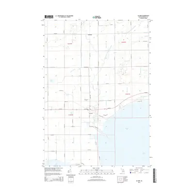
2014 Map of Au Gres
USGS Topo · Published 2014About this map
Au Gres serves as the focal point of this coastal Michigan landscape, situated where the Au Gres River empties into the northern reaches of Saginaw Bay. The settlement pattern follows the shoreline and the river's path, with Linwood Cem and several residential streets marking the community's footprint. To the north, the small settlement of Santiago anchors a rural grid defined by an intricate network of agricultural drainage systems, including Chief Cr Drain and the Old Channel East Branch Au Gres River. The terrain is notably low-lying, characterized by numerous named drains and small bodies of water like Duck Lake and Mud Lake. This 2014 survey illustrates the modern drainage infrastructure required to manage the flat coastal plains bordering Lake Huron, revealing how early waterways have been modified into channels like Schnitzelbank Cr to support the surrounding landscape.
Find a feature on this map
74 named features on this map. Tap any name to fly to it.
Don’t see what you’re looking for? This feature index may not catch every label — zoom into the map to look around manually.
Map Details
Editions of this 2014 Au Gres Map
This is the sole edition of this map. No revisions or reprints were ever made.
Other maps of this area

1954 · Flint
USGS Topo · 1:250,000

1954 · Tawas City
USGS Topo · 1:250,000

1958 · Flint
USGS Topo · 1:250,000

1958 · Tawas City
USGS Topo · 1:250,000

1966 · Point Lookout
USGS Topo · 1:24,000

1966 · Au Gres
USGS Topo · 1:24,000

1966 · Alabaster
USGS Topo · 1:24,000

1966 · National City
USGS Topo · 1:24,000
1967 · Standish NE
USGS Topo · 1:24,000

1968 · Whittemore
USGS Topo · 1:24,000