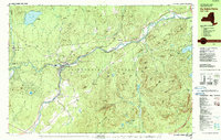
1978 Map of Au Sable Forks
USGS Topo · Published 1990About this map
Ausable River waters converge at Au Sable Forks, where the West and East branches meet within the northeastern boundary of Adirondack Park. In the late 1970s, this landscape shows a legacy of industry and transition, with the Delaware and Hudson railroad line skirting the riverbanks through Rogers and Clintonville. The area's manufacturing and mineral history is evidenced by several Quarries and the presence of established hamlets like Black Brook and Rome.
Find a feature on this map
105 named features on this map. Tap any name to fly to it.
Don’t see what you’re looking for? This feature index may not catch every label — zoom into the map to look around manually.
Map Details
Editions of this 1978 Au Sable Forks Map
3 editions found
Other maps of this area

1894 · Plattsburg
USGS Topo · 1:62,500

1895 · Willsboro
USGS Topo · 1:62,500

1895 · Ausable
USGS Topo · 1:62,500

1896 · Lake Placid
USGS Topo · 1:62,500

1898 · Lake Placid
USGS Topo · 1:62,500

1903 · Ausable
USGS Topo · 1:62,500

1906 · Plattsburg
USGS Topo · 1:62,500

1911 · Lyon Mountain
USGS Topo · 1:62,500

1913 · Dannemora
USGS Topo · 1:62,500

1913 · Lyon Mountain
USGS Topo · 1:62,500