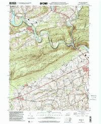
1999 Map of Auburn
USGS Topo · Published 2001About this map
Blue Mountain serves as the dominant topographic divider on this map, separating the river-valley settlements to the north from the rolling farmland of the south. The Schuylkill River and Little Schuylkill River converge near Port Clinton, a site traditionally vital to the regional transportation network. The northern half of the map is defined by industrial and residential clusters like Auburn and Landingville, while the southern reaches near Shartlesville maintain a more rural character.
Find a feature on this map
38 named features on this map. Tap any name to fly to it.
Don’t see what you’re looking for? This feature index may not catch every label — zoom into the map to look around manually.
Map Details
Editions of this 1999 Auburn Map
This is the sole edition of this map. No revisions or reprints were ever made.
Other maps of this area

1889 · Pottsville
USGS Topo · 1:62,500

1891 · Pottsville
USGS Topo · 1:62,500

1894 · Reading
USGS Topo · 1:62,500

1902 · Wernersville
USGS Topo · 1:62,500

1909 · Hamburg
USGS Topo · 1:62,500

1911 · Hamburg
USGS Topo · 1:62,500

1913 · Reading
USGS Topo · 1:62,500

1915 · Reading
USGS Topo · 1:62,500

1943 · Wernersville
USGS Topo · 1:62,500

1944 · Reading
USGS Topo · 1:62,500