
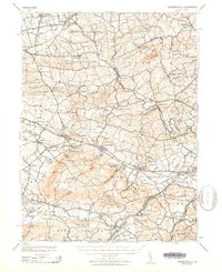
1943 Map of Wernersville
USGS Topo · Published 1943About this map
Wernersville State Hospital and the nearby Bethany Orphans Home stand as prominent institutions in this 1943 landscape, a period when the Pennsylvania countryside was dotted with specialized religious and social facilities. The region is defined by a series of prominent summits, including Eagle Peak and Cushion Peak, which rise above the surrounding farmland of Heidelberg and South Heidelberg. The Reading railroad provides a critical artery through the southern valley, connecting established settlements like Womelsdorf, Robesonia, and Sinking Spring.
Find a feature on this map
84 named features on this map. Tap any name to fly to it.
Don’t see what you’re looking for? This feature index may not catch every label — zoom into the map to look around manually.
Map Details
Editions of this 1943 Wernersville Map
2 editions found
Other maps of this area

1889 · Pottsville
USGS Topo · 1:62,500

1891 · Pottsville
USGS Topo · 1:62,500

1891 · Lebanon
USGS Topo · 1:62,500

1892 · Pine Grove
USGS Topo · 1:62,500

1893 · Lebanon
USGS Topo · 1:62,500

1894 · Reading
USGS Topo · 1:62,500

1899 · Lebanon
USGS Topo · 1:62,500

1902 · Wernersville
USGS Topo · 1:62,500

1902 · Lancaster
USGS Topo · 1:62,500

1904 · Lancaster
USGS Topo · 1:62,500