1943 Map of Wernersville
USGS Topo · Published 1953About this map
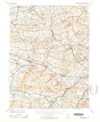
The rolling agricultural lands and institutional hubs of central Pennsylvania are meticulously documented in this mid-century Army and USGS survey. The landscape is punctuated by large-scale social and religious complexes, such as the sprawling grounds of the Wernersville State Hospital and the nearby Bethany Orphans Home. Between the southern ridge of Eagle Peak and the northern reaches of the Swatara Creek, the region is organized into historical townships like Heidelberg and Jefferson, where small boroughs and crossroads connect a network of rural schools and churches.
Find a feature on this map
93 named features on this map. Tap any name to fly to it.
Don’t see what you’re looking for? This feature index may not catch every label — zoom into the map to look around manually.
Map Details
Editions of this 1943 Wernersville Map
2 editions found

Other maps of this area

1889 · Pottsville
USGS Topo · 1:62,500

1891 · Pottsville
USGS Topo · 1:62,500

1891 · Lebanon
USGS Topo · 1:62,500

1892 · Pine Grove
USGS Topo · 1:62,500

1893 · Lebanon
USGS Topo · 1:62,500

1894 · Reading
USGS Topo · 1:62,500

1899 · Lebanon
USGS Topo · 1:62,500

1902 · Wernersville
USGS Topo · 1:62,500

1902 · Lancaster
USGS Topo · 1:62,500

1904 · Lancaster
USGS Topo · 1:62,500