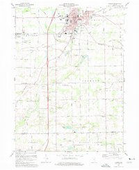
1973 Map of Auburn
USGS Topo · Published 1975About this map
Auburn serves as the focal point of this northeast Indiana landscape, revealing a city defined by its civic infrastructure and rail heritage in the early 1970s. The town core is dense with local history landmarks, including the Courthouse, Library, and Harrison Sch, while the presence of the Baltimore and Ohio railroad corridor highlights the industrial connectivity of the era. To the south and west, the terrain transitions into a grid of rural farmsteads and agricultural townships like Jackson and Butler, where smaller communities such as New Era and Saint Johns persist alongside country landmarks like Meese Ch and Salem Ch. The map provides an intricate look at the region's drainage system, with numerous man-made channels like Peckhart Ditch and Dosch Ditch engineered to manage the headwaters of Cedar Creek. This survey captures a moment of modern transition, balancing traditional cemeteries like Roselawn Cem with then-contemporary developments like the Auburn-DeKalb Airport.
Find a feature on this map
75 named features on this map. Tap any name to fly to it.
Don’t see what you’re looking for? This feature index may not catch every label — zoom into the map to look around manually.
Map Details
Editions of this 1973 Auburn Map
2 editions found
Other maps of this area

1953 · Fort Wayne
USGS Topo · 1:250,000

1955 · Corunna
USGS Topo · 1:24,000

1956 · Fort Wayne
USGS Topo · 1:250,000

1956 · Cedarville
USGS Topo · 1:24,000

1957 · Auburn
USGS Topo · 1:24,000

1957 · Waterloo
USGS Topo · 1:24,000

1957 · Huntertown
USGS Topo · 1:24,000

1957 · Garrett
USGS Topo · 1:24,000

1958 · Grabill
USGS Topo · 1:24,000

1958 · Butler West
USGS Topo · 1:24,000