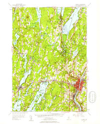
1956 Map of Augusta
USGS Topo · Published 1958About this map
Augusta serves as the focal point of this Kennebec County landscape in the mid-1950s, situated along the Maine Central railroad corridor. The area is defined by a dense concentration of inland water bodies, including Maranacook Lake, Messalonskee Lake, and Cobbosseecontee Lake, which were well-established as recreation and residential hubs. The map reveals a transition from the urban density of the state capital, featuring landmarks like the State Hospital and Buker Sch, to the smaller outlying villages of Manchester and Belgrade. Rural life is marked by numerous family burial grounds such as Robinson Cem and Dudley Plain Cem, alongside small community institutions like the Smith Memorial Ch in Readfield. The rail infrastructure at Readfield Sta and the placement of the Augusta Golf Course reflect the balance of industry and leisure that shaped the region during this era.
Find a feature on this map
121 named features on this map. Tap any name to fly to it.
Don’t see what you’re looking for? This feature index may not catch every label — zoom into the map to look around manually.
Map Details
Editions of this 1956 Augusta Map
4 editions found
Other maps of this area

1892 · Gardiner
USGS Topo · 1:62,500

1892 · Waterville
USGS Topo · 1:62,500

1892 · Augusta
USGS Topo · 1:62,500

1893 · Vassalboro
USGS Topo · 1:62,500

1893 · Wiscasset
USGS Topo · 1:62,500

1894 · Norridgewock
USGS Topo · 1:62,500

1898 · Norridgewock
USGS Topo · 1:62,500

1898 · Vassalboro
USGS Topo · 1:62,500

1908 · Lewiston
USGS Topo · 1:62,500

1910 · Livermore
USGS Topo · 1:62,500