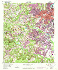
1957 Map of Augusta West
USGS Topo · Published 1973About this map
The Fort Gordon Military Reservation dominates the southwestern quadrant of this landscape, its boundary marking a sharp divide between the densely wooded training grounds and the expanding suburbs of Augusta. Following the Georgia Railroad and the Gordon Highway through the central corridor, one finds a city in transition. The presence of major institutional hubs like the Veterans Administration Hospital and the State Training School reflects the area's mid-century role as a regional center for medical and civic services. To the north, the terrain around Murphy Hills and Raes Creek shows significant residential development in Forest Hills and Westwick, while the Daniel Field airport anchors the eastern urban edge. Scattered throughout the hills are local landmarks like Gardner Grove Ch and Walker Cem, preserving traces of the community's older rural character amidst the postwar growth.
Find a feature on this map
49 named features on this map. Tap any name to fly to it.
Don’t see what you’re looking for? This feature index may not catch every label — zoom into the map to look around manually.
Map Details
Editions of this 1957 Augusta West Map
4 editions found
Other maps of this area

1892 · Mc Cormick
USGS Topo · 1:125,000

1912 · Mc Cormick
USGS Topo · 1:125,000

1920 · Clarks Hill
USGS Topo · 1:48,000

1921 · Augusta
USGS Topo · 1:62,500

1921 · Clarks Hill
USGS Topo · 1:62,500

1922 · Hephzibah
USGS Topo · 1:62,500

1923 · Warrenville
USGS Topo · 1:48,000

1928 · Warrenville
USGS Topo · 1:62,500

1941 · Clarks Hill
USGS Topo · 1:62,500

1942 · Clarks Hill
USGS Topo · 1:62,500