
2015 Map of Aurelia
USGS Topo · Published 2015About this map
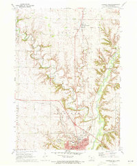
Aurelia serves as the central hub of this northwestern Iowa landscape, where a precise grid of county roads meets the meandering paths of the local waterways. The town's layout is defined by streets like Main St and Walnut St, with Coombs Dr skirting its southern edge. This agricultural region is deeply tied to its drainage network, with the Maple River and its various tributaries, including Maple Cr and Pitcher Cr, carving subtle variations into the prairie. These streams dictated the early placement of farmsteads and transport routes long before the modern highway system was established. Genealogists will find the Pleasant Hill Cem south of the main settlement, a quiet landmark situated along Co Hwy M21. Near the border of Buena Vista Co, Larson Lake provides one of the few standing bodies of water in a terrain otherwise dominated by the rhythmic rise and fall of the creek valleys.
Find a feature on this map
40 named features on this map. Tap any name to fly to it.
Don’t see what you’re looking for? This feature index may not catch every label — zoom into the map to look around manually.
Map Details
Editions of this 2015 Aurelia Map
This is the sole edition of this map. No revisions or reprints were ever made.
Other maps of this area

1954 · Fort Dodge
USGS Topo · 1:250,000

1957 · Fort Dodge
USGS Topo · 1:250,000

1958 · Fort Dodge
USGS Topo · 1:250,000

1969 · Aurelia
USGS Topo · 1:24,000

1969 · Cherokee South
USGS Topo · 1:24,000

1969 · Galva
USGS Topo · 1:24,000

1969 · Quimby SE
USGS Topo · 1:24,000

1971 · Peterson SW
USGS Topo · 1:24,000

1971 · Peterson SE
USGS Topo · 1:24,000
1971 · Cherokee North
USGS Topo · 1:24,000