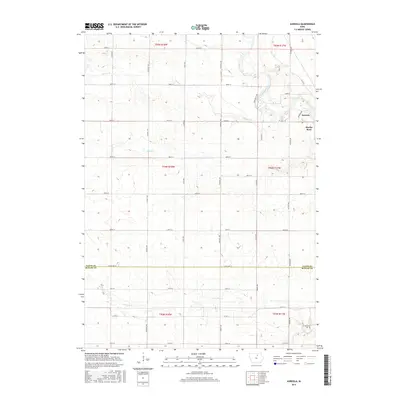
2015 Map of Aureola
USGS Topo · Published 2015About this map
The Shell Rock River winds through the northeastern corner of this terrain, where the small community of Marble Rock and the neighboring settlement of Aureola represent the primary residential hubs. The landscape is defined by the steady transition from the Floyd County plains into Butler County across the Floyd Co Butler Co line, with a dense network of sectional roads like Co Hwy T18 and Corsadally Rd serving the agricultural heartland. Waterways such as Beemis Cr, Ackley Cr, and Coldwater Cr drainage patterns dictate the local topography. For genealogists, the Haselroad Cem in the southeast near Hickory Ave serves as a vital point of interest, marking a historical anchor for the families that settled this portion of north-central Iowa.
Find a feature on this map
40 named features on this map. Tap any name to fly to it.
Don’t see what you’re looking for? This feature index may not catch every label — zoom into the map to look around manually.
Map Details
Editions of this 2015 Aureola Map
This is the sole edition of this map. No revisions or reprints were ever made.
Other maps of this area

1954 · Mason City
USGS Topo · 1:250,000

1954 · Waterloo
USGS Topo · 1:250,000

1955 · Waterloo
USGS Topo · 1:250,000

1957 · Mason City
USGS Topo · 1:250,000

1958 · Mason City
USGS Topo · 1:250,000

1959 · Mason City
USGS Topo · 1:62,500

1959 · Mason City SE
USGS Topo · 1:24,000

1971 · Rockford
USGS Topo · 1:24,000
1971 · Roseville
USGS Topo · 1:24,000

1972 · Dumont North
USGS Topo · 1:24,000