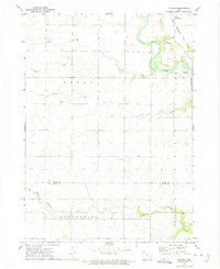
1972 Map of Aureola
USGS Topo · Published 1975About this map
The Shell Rock River meanders through the northeast corner of this landscape, defining the character of the river valley near the settlement of Aureola. In the early 1970s, this portion of Iowa's northern borderlands maintained a distinct agrarian structure, with the Chicago Rock Island and Pacific railroad providing a vital transport corridor along the eastern edge. Local aviation is represented by two private strips, Ludwig Landing Field and Knoop Landing Field, indicating the utility of light aircraft for rural connectivity.
Find a feature on this map
22 named features on this map. Tap any name to fly to it.
Don’t see what you’re looking for? This feature index may not catch every label — zoom into the map to look around manually.
Map Details
Editions of this 1972 Aureola Map
This is the sole edition of this map. No revisions or reprints were ever made.
Other maps of this area

1954 · Mason City
USGS Topo · 1:250,000

1954 · Waterloo
USGS Topo · 1:250,000

1955 · Waterloo
USGS Topo · 1:250,000

1957 · Mason City
USGS Topo · 1:250,000

1958 · Mason City
USGS Topo · 1:250,000

1959 · Mason City
USGS Topo · 1:62,500

1959 · Mason City SE
USGS Topo · 1:24,000

1971 · Rockford
USGS Topo · 1:24,000
1971 · Roseville
USGS Topo · 1:24,000

1972 · Dumont North
USGS Topo · 1:24,000