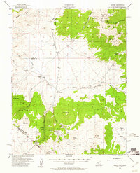
1956 Map of Aurora
USGS Topo · Published 1961About this map
Aurora (Historic Ruins) serves as a focal point for this mid-century survey of the high desert landscape straddling the Nevada-California border. The map documents the remnants of a once-thriving mining district, detailing the site of Aurora and nearby Del Monte against the backdrop of the Toiyabe National Forest. Evidence of industrial history is found at the Borealis Mine and Chesco Mine, while the Von Schmidt Line marks a significant historical surveying boundary nearby. Ranching and travel hubs like Ninemile Ranch and Fletcher are connected by rugged routes such as the Aldrich Grade and Lucky Boy Trail. The topography is dominated by volcanic features like Aurora Crater and prominent summits including Corey Peak and the Brawley Peaks, which rise above the arid flats of Alkali Valley.
Find a feature on this map
43 named features on this map. Tap any name to fly to it.
Don’t see what you’re looking for? This feature index may not catch every label — zoom into the map to look around manually.
Map Details
Editions of this 1956 Aurora Map
3 editions found

Other maps of this area

1891 · Wellington
USGS Topo · 1:125,000

1893 · Wellington
USGS Topo · 1:125,000

1909 · Hawthorne
USGS Topo · 1:250,000

1909 · Bridgeport
USGS Topo · 1:125,000

1911 · Bridgeport
USGS Topo · 1:125,000

1911 · Hawthorne
USGS Topo · 1:250,000

1915 · Hawthorne
USGS Topo · 1:250,000

1920 · Bridgeport
USGS Topo · 1:125,000

1948 · Walker Lake
USGS Topo · 1:250,000

1955 · Powell Mtn
USGS Topo · 1:62,500