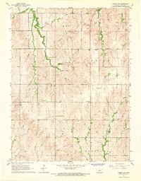
1965 Map of Aurora NW
USGS Topo · Published 1966About this map
Cloud County's rural townships of Arion, Center, Lyon, and Meredith are defined here by a network of winding creek beds and mid-century utility infrastructure. The landscape is deeply carved by Wolf Creek and Pipe Creek, while long Pipeline corridors and the Radio Towers (KFRM) reflect the industrial reach into these farming communities during the 1960s. For those tracing family roots in this part of Kansas, the sheet preserves the locations of several small local burial grounds, including Kindel Cem, Wilcox Cem, and Hall Cem. These landmarks, along with New Hope Ch and the Hopewell Sch, mark the social centers of a dispersed agricultural population. The map illustrates a transitional era where traditional rural landmarks like country schools remained fixed in the landscape even as modern infrastructure began to cross the drainage divides of Yockey Creek and the West Branch Oak Creek.
Find a feature on this map
16 named features on this map. Tap any name to fly to it.
Don’t see what you’re looking for? This feature index may not catch every label — zoom into the map to look around manually.
Map Details
Editions of this 1965 Aurora NW Map
This is the sole edition of this map. No revisions or reprints were ever made.
Other maps of this area

1892 · Concordia
USGS Topo · 1:125,000

1892 · Minneapolis
USGS Topo · 1:125,000

1952 · Glasco
USGS Topo · 1:24,000

1953 · Glasco NE
USGS Topo · 1:24,000

1955 · Manhattan
USGS Topo · 1:250,000

1956 · Manhattan
USGS Topo · 1:250,000

1957 · Manhattan
USGS Topo · 1:250,000

1964 · Lamar
USGS Topo · 1:24,000

1965 · Aurora
USGS Topo · 1:24,000
1965 · Aurora SW
USGS Topo · 1:24,000