
1965 Map of Aurora
USGS Topo · Published 1966About this map
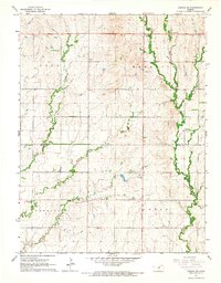
The town of Aurora serves as the central hub of this mid-1960s Kansas landscape, situated where the Atchison Topeka and Santa Fe railroad cuts across the agricultural plains of Cloud County. The map reflects a deeply established rural community, organized through township boundaries like Nelson, Center, and Aurora. Local history is preserved in the distribution of country institutions, including Fairview Sch, Enterprise Sch, and the Rocky Ridge Sch, alongside sacred sites such as St Peters Cem and Princeville Cem. The terrain is defined by a network of drainage systems, including Elm Creek, Middle Creek, and East Pipe Creek, which carve gentle valleys through the prairie. Industrial activity is localized in several Gravel Pits and Claypits, suggesting the extraction of local resources to support the regional infrastructure during this era of rural development.
Find a feature on this map
21 named features on this map. Tap any name to fly to it.
Don’t see what you’re looking for? This feature index may not catch every label — zoom into the map to look around manually.
Map Details
Editions of this 1965 Aurora Map
This is the sole edition of this map. No revisions or reprints were ever made.
Other maps of this area

1891 · Clay Center
USGS Topo · 1:125,000

1892 · Concordia
USGS Topo · 1:125,000

1892 · Minneapolis
USGS Topo · 1:125,000

1893 · Washington
USGS Topo · 1:125,000

1955 · Manhattan
USGS Topo · 1:250,000

1956 · Manhattan
USGS Topo · 1:250,000

1957 · Manhattan
USGS Topo · 1:250,000

1964 · Lamar
USGS Topo · 1:24,000

1964 · Miltonvale
USGS Topo · 1:24,000
1965 · Aurora SW
USGS Topo · 1:24,000