
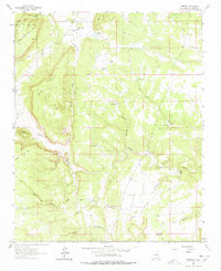
1963 Map of Aurora
USGS Topo · Published 1966About this map
Gonzales Ranch sits at the northern edge of this high-plateau landscape, serving as a hub for local life with the Santa Teresita Ch and the Gonzales Ranch Sch. The topography is defined by the massive Mesa Sola and deep incisions of the Cañon Blanco, illustrating a territory where ranching and water management were central to survival. Further south, the settlement of Aurora is situated near the Arroyo Guajalote, surrounded by family-named landmarks such as the Pablo Sena Ranch and Benevides Ranch. These sites, along with isolated improvements like Bustos Well and Laguna Seca, reveal how early New Mexico inhabitants adapted to the arid environment by utilizing natural depressions and arroyos. The map also shows a portion of the Santa Fe Nat For, marking the transition from open grazing lands to protected timber country.
Find a feature on this map
38 named features on this map. Tap any name to fly to it.
Don’t see what you’re looking for? This feature index may not catch every label — zoom into the map to look around manually.
Map Details
Editions of this 1963 Aurora Map
2 editions found
Other maps of this area

1890 · Bernal
USGS Topo · 1:125,000

1891 · Bernal
USGS Topo · 1:125,000

1894 · Bernal
USGS Topo · 1:125,000

1894 · Lamy
USGS Topo · 1:125,000

1954 · Santa Fe
USGS Topo · 1:250,000

1958 · Santa Fe
USGS Topo · 1:250,000

1960 · Villanueva
USGS Topo · 1:62,500

1963 · Jacinto Mesa
USGS Topo · 1:24,000
1963 · Potrillo Hill
USGS Topo · 1:24,000
1963 · San Juan
USGS Topo · 1:24,000