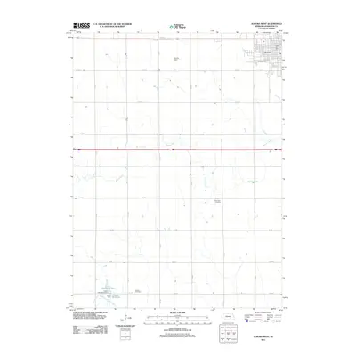
2011 Map of Aurora West
USGS Topo · Published 2011About this map
The western outskirts of Aurora and the surrounding agricultural landscape of Hamilton County are mapped here in the early twenty-first century. The grid-based settlement pattern is defined by a dense network of local roads such as S K Rd and W 8 Rd, which segment the terrain into precise square-mile sections. This orderly arrangement is interrupted only by the winding course of Beaver Creek as it meanders eastward toward the city. To the south, the North Branch West Fork Big Blue River feeds into the Kostal Reservoir, a local water management feature held by the Kostal-Hawthorne Dam. For those tracing local heritage, the map identifies the Prairie Gem Cemetery and Seaton Cemetery, quiet landmarks that anchor this rural community. The concentration of development remains focused near the Aurora Post Office and along Railroad Ave, reflecting the town's historical orientation toward the rail corridor.
Find a feature on this map
29 named features on this map. Tap any name to fly to it.
Don’t see what you’re looking for? This feature index may not catch every label — zoom into the map to look around manually.
Map Details
Editions of this 2011 Aurora West Map
This is the sole edition of this map. No revisions or reprints were ever made.
Other maps of this area

1898 · York
USGS Topo · 1:125,000

1898 · Grand Island
USGS Topo · 1:125,000

1899 · York
USGS Topo · 1:125,000

1955 · Lincoln
USGS Topo · 1:250,000

1955 · Grand Island
USGS Topo · 1:250,000

1957 · Lincoln
USGS Topo · 1:250,000

1957 · Grand Island
USGS Topo · 1:250,000

1958 · Grand Island
USGS Topo · 1:250,000

1958 · Lincoln
USGS Topo · 1:250,000
1962 · Phillips
USGS Topo · 1:24,000