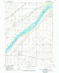
1962 Map of Phillips
USGS Topo · Published 1964About this map
The Platte River dominates this Hamilton County landscape, serving as a natural divide defined by braided channels and features like Guendel Island. Surveyed as part of a Department of the Interior program for the development of the Missouri River Basin, the map illustrates a rural Nebraska economy centered on the river and rail. The village of Phillips sits in the southern portion of the quadrangle along the Chicago Burlington and Quincy railroad, while the Union Pacific line cuts through the northwest corner at Lockwood.
Find a feature on this map
23 named features on this map. Tap any name to fly to it.
Don’t see what you’re looking for? This feature index may not catch every label — zoom into the map to look around manually.
Map Details
Editions of this 1962 Phillips Map
This is the sole edition of this map. No revisions or reprints were ever made.
Other maps of this area

1892 · Grand Island
USGS Topo · 1:62,500

1895 · Grand Island
USGS Topo · 1:62,500

1898 · Grand Island
USGS Topo · 1:125,000

1899 · St. Paul
USGS Topo · 1:125,000

1955 · Broken Bow
USGS Topo · 1:250,000

1955 · Grand Island
USGS Topo · 1:250,000

1956 · Broken Bow
USGS Topo · 1:250,000

1957 · Grand Island
USGS Topo · 1:250,000

1958 · Grand Island
USGS Topo · 1:250,000
1961 · St. Libory
USGS Topo · 1:24,000