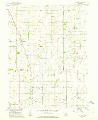
1961 Map of St. Libory
USGS Topo · Published 1963About this map
Agricultural life in central Nebraska is clearly defined by the section lines and rural institutions documented in this 1961 field-checked survey. The St Libory settlement serves as a primary hub along the Union Pacific tracks, while the smaller community of Worms anchors the eastern prairie. The landscape is a network of small school districts and country churches, including Emmanuel Ch and Pleasant Ridge Sch, which highlight the density of early 1960s rural education before consolidation. Significant watercourses like Prairie Creek and Silver Creek meander across the townships, often flanked by numerous wells that suggest the area's reliance on groundwater for its farmstead economy. The map also records localized history through sites like the Norwegian Cem and Weigert Cem, providing precise locations for genealogical research within Howard, Hall, and Merrick counties.
Find a feature on this map
24 named features on this map. Tap any name to fly to it.
Don’t see what you’re looking for? This feature index may not catch every label — zoom into the map to look around manually.
Map Details
Editions of this 1961 St. Libory Map
This is the sole edition of this map. No revisions or reprints were ever made.
Other maps of this area

1892 · Grand Island
USGS Topo · 1:62,500

1895 · Grand Island
USGS Topo · 1:62,500

1898 · Grand Island
USGS Topo · 1:125,000

1899 · St. Paul
USGS Topo · 1:125,000

1955 · Broken Bow
USGS Topo · 1:250,000

1955 · Grand Island
USGS Topo · 1:250,000

1956 · Broken Bow
USGS Topo · 1:250,000

1957 · Grand Island
USGS Topo · 1:250,000

1958 · Grand Island
USGS Topo · 1:250,000
1960 · St. Paul
USGS Topo · 1:24,000