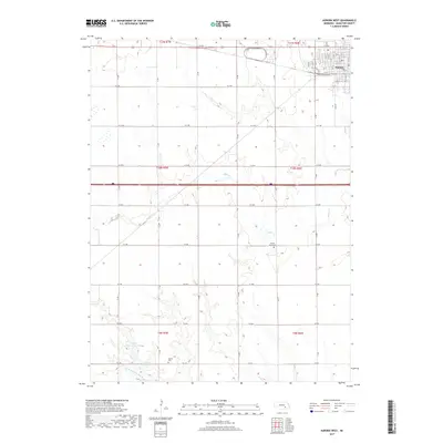
2017 Map of Aurora West
USGS Topo · Published 2017About this map
The western edges of Aurora anchor this landscape, where the residential grid gives way to the section-line roads and agricultural tracts of Hamilton County. This 2017 survey by the U.S. Geological Survey illustrates the transition from the city’s named streets like Mark St and Railroad Ave to the open prairie drainages. Water management is a central theme of the terrain, highlighted by the Kostal-Hawthorne Dam and Kostal Reservoir in the southwest corner. The land is defined by the winding course of Beaver Cr and the N Br W Fork Big Blue River, while the rural history of the area is preserved in sites like the Prairie Gem Cem and Seaton Cem. The map reveals a highly structured landscape where modern infrastructure and historic land divisions meet.
Find a feature on this map
57 named features on this map. Tap any name to fly to it.
Don’t see what you’re looking for? This feature index may not catch every label — zoom into the map to look around manually.
Map Details
Editions of this 2017 Aurora West Map
This is the sole edition of this map. No revisions or reprints were ever made.
Other maps of this area

1898 · York
USGS Topo · 1:125,000

1898 · Grand Island
USGS Topo · 1:125,000

1899 · York
USGS Topo · 1:125,000

1955 · Lincoln
USGS Topo · 1:250,000

1955 · Grand Island
USGS Topo · 1:250,000

1957 · Lincoln
USGS Topo · 1:250,000

1957 · Grand Island
USGS Topo · 1:250,000

1958 · Grand Island
USGS Topo · 1:250,000

1958 · Lincoln
USGS Topo · 1:250,000
1962 · Phillips
USGS Topo · 1:24,000