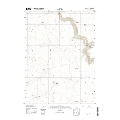
2013 Map of Austin Butte
USGS Topo · Published 2013About this map
Bruneau Canyon dominates the eastern half of this high-desert landscape in Owyhee County, where the Bruneau River carves a deep, winding path through the plateau. This 2013 survey illustrates the dramatic elevation shifts between the canyon floor and the surrounding Bruneau Desert. Local landmarks such as Austin Butte and Twin Butte rise above the flat expanse, providing critical orientation points for those navigating the arid terrain. The map details a network of ephemeral water sources including Salvador Lake, Rock Lake, and White Lake, which are characteristic of this region's hydrology. Transportation across this section of the Idaho backcountry is defined by the Blackstone Grasmere Rd, which connects the high flats near Big Hill to the wider county road system. The confluence with the East Fork Bruneau Canyon near the eastern margin highlights the complex drainage system feeding the main river gorge.
Find a feature on this map
20 named features on this map. Tap any name to fly to it.
Don’t see what you’re looking for? This feature index may not catch every label — zoom into the map to look around manually.
Map Details
Editions of this 2013 Austin Butte Map
This is the sole edition of this map. No revisions or reprints were ever made.
Other maps of this area

1955 · Twin Falls
USGS Topo · 1:250,000

1956 · Big Hill
USGS Topo · 1:62,500

1956 · Winter Camp
USGS Topo · 1:62,500

1958 · Twin Falls
USGS Topo · 1:250,000

1979 · Stiff Tree Draw
USGS Topo · 1:24,000

1979 · Blackstone Reservoir
USGS Topo · 1:24,000

1979 · Cave Draw
USGS Topo · 1:24,000
1980 · Austin Butte
USGS Topo · 1:24,000
1980 · Table Butte
USGS Topo · 1:24,000
1980 · Broken Wagon Flat
USGS Topo · 1:24,000