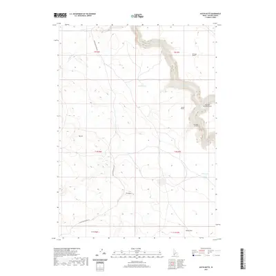
2020 Map of Austin Butte
USGS Topo · Published 2020About this map
The Bruneau River carves a dramatic path through the high desert of Owyhee County, defining the eastern half of this modern topographical study. The river sits at the bottom of steep-walled formations, including the Bruneau Canyon and its prominent East Fork Bruneau Canyon. This arid landscape is punctuated by isolated water sources such as Salvador Lake, White Lake, and the spring-fed Miller Water. The terrain rises from the Bruneau Desert toward distinctive landmarks like Austin Butte and Twin Butte. Human infrastructure is minimal in this remote corner of Idaho, centered primarily on the winding Blackstone Grasmere Rd, which provides the only major access through the townships. The map illustrates the stark contrast between the flat desert plains and the deep, convoluted river systems that dominate the regional geography.
Find a feature on this map
19 named features on this map. Tap any name to fly to it.
Don’t see what you’re looking for? This feature index may not catch every label — zoom into the map to look around manually.
Map Details
Editions of this 2020 Austin Butte Map
This is the sole edition of this map. No revisions or reprints were ever made.
Other maps of this area

1955 · Twin Falls
USGS Topo · 1:250,000

1956 · Big Hill
USGS Topo · 1:62,500

1956 · Winter Camp
USGS Topo · 1:62,500

1958 · Twin Falls
USGS Topo · 1:250,000

1979 · Stiff Tree Draw
USGS Topo · 1:24,000

1979 · Blackstone Reservoir
USGS Topo · 1:24,000

1979 · Cave Draw
USGS Topo · 1:24,000
1980 · Austin Butte
USGS Topo · 1:24,000
1980 · Table Butte
USGS Topo · 1:24,000
1980 · Broken Wagon Flat
USGS Topo · 1:24,000