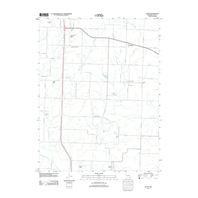
2012 Map of Austin
USGS Topo · Published 2012About this map
Eightmile Creek and its various tributaries, including Tennessee Creek and Elm Branch, carve through the rural landscape of Cass County. This area of Missouri maintains its agricultural character, evidenced by the scattered distribution of small settlements like Austin, Daugherty, and Lone Tree. The map provides significant value for genealogical researchers, as it identifies several historic rural education sites such as Houston School, Elm Branch School, and Mullin School, alongside resting places including Pleasant Valley Cemetery and Vansandt Cemetery. Aviation in the region is anchored by the Lawrence Smith Memorial Airport, situated near the prominent elevation of Snowball Hill. The terrain is further defined by several family-named hills and private lakes like Hartzler Lake and Kurzweil Lake, reflecting long-standing local land ownership patterns south of the South Grand River.
Find a feature on this map
69 named features on this map. Tap any name to fly to it.
Don’t see what you’re looking for? This feature index may not catch every label — zoom into the map to look around manually.
Map Details
Editions of this 2012 Austin Map
This is the sole edition of this map. No revisions or reprints were ever made.
Other maps of this area

1887 · Harrisonville
USGS Topo · 1:125,000

1887 · Butler
USGS Topo · 1:125,000

1892 · Harrisonville
USGS Topo · 1:125,000

1894 · Harrisonville
USGS Topo · 1:125,000

1894 · Butler
USGS Topo · 1:125,000

1947 · Lawrence
USGS Topo · 1:250,000

1950 · Lawrence
USGS Topo · 1:250,000
1953 · Everett
USGS Topo · 1:24,000

1954 · Harrisonville
USGS Topo · 1:24,000
1954 · East Lynne
USGS Topo · 1:24,000