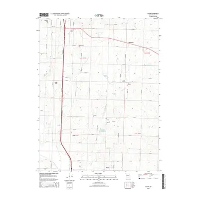
2014 Map of Austin
USGS Topo · Published 2014About this map
Snowball Hill and Bodenhammer Hill rise above the agricultural plains of Cass County, defining a landscape shaped by the headwaters of the South Grand River. This 2014 survey captures a rural Missouri corridor where modern infrastructure meets historical local landmarks. The Lawrence Smith Memorial Airport occupies the northern section, while the southern reaches center on the community of Austin. The map documents a network of small settlements and family-named landmarks, including Daugherty and Lone Tree, alongside several significant burial grounds such as Vansandt Cemetery and Pleasant Valley Cemetery. Water features like Eightmile Cr and Tennessee Cr meander through the townships, feeding local impoundments such as Hartzler Lake and Kurzweil Lake. This record is particularly valuable for tracing the placement of rural roads and section lines that have organized the region since its early development.
Find a feature on this map
74 named features on this map. Tap any name to fly to it.
Don’t see what you’re looking for? This feature index may not catch every label — zoom into the map to look around manually.
Map Details
Editions of this 2014 Austin Map
This is the sole edition of this map. No revisions or reprints were ever made.
Other maps of this area

1887 · Harrisonville
USGS Topo · 1:125,000

1887 · Butler
USGS Topo · 1:125,000

1892 · Harrisonville
USGS Topo · 1:125,000

1894 · Harrisonville
USGS Topo · 1:125,000

1894 · Butler
USGS Topo · 1:125,000

1947 · Lawrence
USGS Topo · 1:250,000

1950 · Lawrence
USGS Topo · 1:250,000
1953 · Everett
USGS Topo · 1:24,000

1954 · Harrisonville
USGS Topo · 1:24,000
1954 · East Lynne
USGS Topo · 1:24,000