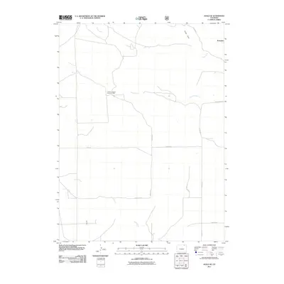
2011 Map of Avalo SE
USGS Topo · Published 2011About this map
Westplains sits at the northeastern edge of this Weld County landscape, characterized by a sparse network of county roads and seasonal drainage systems. The terrain is defined by the paths of Cedar Creek, Twomile Creek, and Spring Creek, which navigate the open country alongside Spring Draw. Human intervention in the natural hydrology is evidenced by the Lemon- Erickson Number 1 Dam, which manages local water resources. The infrastructure is primarily defined by a grid of rural routes including County Rd 7 and Co Rd 112, illustrating the sprawling, low-density settlement patterns typical of the High Plains during the early 21st century.
Find a feature on this map
16 named features on this map. Tap any name to fly to it.
Don’t see what you’re looking for? This feature index may not catch every label — zoom into the map to look around manually.
Map Details
Editions of this 2011 Avalo SE Map
This is the sole edition of this map. No revisions or reprints were ever made.
Other maps of this area

1951 · Wild Horse Lake
USGS Topo · 1:24,000

1954 · Sterling
USGS Topo · 1:250,000

1958 · Sterling
USGS Topo · 1:250,000

1977 · Dipper Spring
USGS Topo · 1:24,000
1977 · Battle Canyon
USGS Topo · 1:24,000

1977 · Stoneham NE
USGS Topo · 1:24,000

1977 · Avalo SE
USGS Topo · 1:24,000

1978 · Stoneham NW
USGS Topo · 1:24,000
1978 · Chimney Canyons
USGS Topo · 1:24,000
1978 · Avalo
USGS Topo · 1:24,000