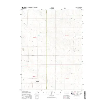
2016 Map of Avalo SE
USGS Topo · Published 2016About this map
Pawnee National Grassland dominates the southern reaches of this landscape, marking a protected expanse of the high plains along the border of Weld and Logan counties. The terrain is defined by a series of intermittent drainages and draws that carve through the open country, including Twomile Cr and Spring Draw in the north, while Spring Cr and Brush Cr navigate the southern sections. A rare point of permanent water management appears at the Lemon-Erickson Reservoir Number 1, reflecting the region's historical reliance on water storage for ranching and agriculture. The grid of county roads, such as Co RD 112 and Co RD 7, follows the rigid section lines of the Public Land Survey System, illustrating how human settlement and transit remain bound to the structured geometry of the prairie.
Find a feature on this map
18 named features on this map. Tap any name to fly to it.
Don’t see what you’re looking for? This feature index may not catch every label — zoom into the map to look around manually.
Map Details
Editions of this 2016 Avalo SE Map
This is the sole edition of this map. No revisions or reprints were ever made.
Other maps of this area

1951 · Wild Horse Lake
USGS Topo · 1:24,000

1954 · Sterling
USGS Topo · 1:250,000

1958 · Sterling
USGS Topo · 1:250,000

1977 · Dipper Spring
USGS Topo · 1:24,000
1977 · Battle Canyon
USGS Topo · 1:24,000

1977 · Stoneham NE
USGS Topo · 1:24,000

1977 · Avalo SE
USGS Topo · 1:24,000

1978 · Stoneham NW
USGS Topo · 1:24,000
1978 · Chimney Canyons
USGS Topo · 1:24,000
1978 · Avalo
USGS Topo · 1:24,000