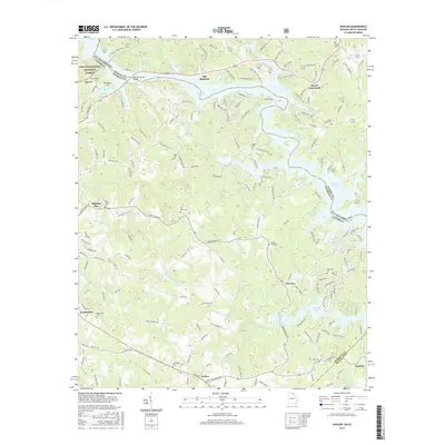
2017 Map of Avalon
USGS Topo · Published 2017About this map
The Chattahoochee National Forest marks the western edge of this landscape, where the Chattahoochee River defines the border between Georgia and South Carolina. Centered in Stephens County, the area features a network of small settlements and family-named landmarks that speak to the region's agricultural and rural foundations. Settlements such as Avalon, Eastanollee, and Old Madison are connected by local routes like Yow Mill Rd and Old Jarrett Rd, while the terrain is deeply influenced by the fingers of Hartwell Lake extending from the east.
Find a feature on this map
158 named features on this map. Tap any name to fly to it.
Don’t see what you’re looking for? This feature index may not catch every label — zoom into the map to look around manually.
Map Details
Editions of this 2017 Avalon Map
This is the sole edition of this map. No revisions or reprints were ever made.
Other maps of this area

1886 · Walhalla
USGS Topo · 1:125,000

1891 · Carnesville
USGS Topo · 1:125,000

1892 · Walhalla
USGS Topo · 1:125,000

1896 · Walhalla
USGS Topo · 1:125,000

1954 · Greenville
USGS Topo · 1:250,000

1957 · Tugaloo Lake
USGS Topo · 1:24,000

1958 · Greenville
USGS Topo · 1:250,000

1959 · Lavonia
USGS Topo · 1:24,000

1960 · Martin
USGS Topo · 1:24,000
1963 · Westminster
USGS Topo · 1:24,000