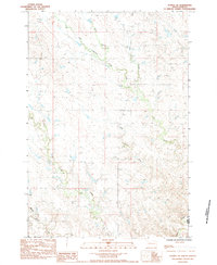
1983 Map of Avance SE
USGS Topo · Published 1984About this map
The settlement of Zeal anchors this section of the western South Dakota plains, where the local drainage patterns define the ranching landscape of the early 1980s. The map illustrates a complex hydraulic network centered on Turtle Creek, which is fed by the West Branch, North Branch, and East Branch. These waterways carve through the terrain, providing essential water sources in an otherwise arid environment. To the south, the terrain shifts toward the Middle and main Cherry Creek systems. This survey, compiled from 1975 aerial photography, documents the sparse but vital infrastructure of the high plains, showing the transition from the Brushy Creek drainage toward the county line. The placement of Zeal relative to these seasonal watercourses highlights the importance of reliable water for homesteading and grazing in this part of the state.
Find a feature on this map
9 named features on this map. Tap any name to fly to it.
Don’t see what you’re looking for? This feature index may not catch every label — zoom into the map to look around manually.
Map Details
Editions of this 1983 Avance SE Map
This is the sole edition of this map. No revisions or reprints were ever made.
Other maps of this area

1953 · Rapid City
USGS Topo · 1:250,000

1954 · Pierre
USGS Topo · 1:250,000

1957 · Rapid City
USGS Topo · 1:250,000

1958 · Pierre
USGS Topo · 1:250,000

1982 · Chasing Hawk Draw
USGS Topo · 1:24,000

1982 · Dead Horse Draw
USGS Topo · 1:24,000

1982 · Bessie Butte
USGS Topo · 1:24,000
1983 · Avance
USGS Topo · 1:24,000
1983 · Lemmon Creek
USGS Topo · 1:24,000
1983 · Reed Dam
USGS Topo · 1:24,000