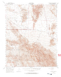
1948 Map of Avawatz Pass
USGS Topo · Published 1969About this map
Death Valley dominates the northern reaches of this map, where the arid basin meets the formidable Ibex Hills and the shifting sands of the Ibex Dunes. In this post-war survey, the landscape is defined by the extraction of minerals and the essential search for water. Notable mining operations such as the Ibex Mine, Superior Mine, and Whiteside Mine are positioned against the steep slopes, while the presence of Saratoga Spr and Old Mormon Spr highlights the critical importance of reliable water sources in the high desert.
Find a feature on this map
27 named features on this map. Tap any name to fly to it.
Don’t see what you’re looking for? This feature index may not catch every label — zoom into the map to look around manually.
Map Details
Editions of this 1948 Avawatz Pass Map
2 editions found
Other maps of this area

1933 · Avawatz Mountains
USGS Topo · 1:250,000

1947 · Trona
USGS Topo · 1:250,000

1948 · Red Pass Lake
USGS Topo · 1:62,500

1948 · Trona
USGS Topo · 1:250,000

1948 · Leach Lake
USGS Topo · 1:62,500

1948 · Avawatz Pass
USGS Topo · 1:62,500

1948 · Tiefort Mountains
USGS Topo · 1:62,500

1950 · Confidence Hills
USGS Topo · 1:62,500

1950 · Tecopa
USGS Topo · 1:62,500

1951 · Tiefort Mountains
USGS Topo · 1:62,500