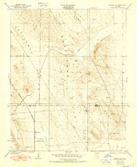
1950 Map of Avenal Gap
USGS Topo · Published 1950About this map
Kettleman Hills terrain dominates this landscape where the Kings Co Kern Co boundary line divides the Middle Dome and South Dome. The map illustrates a distinctive transition between the Kettleman Plain and the Antelope Plain, linked by the geologic corridor of Avenal Gap. This 1950 edition reflects surveys from 1930, documenting the remote settlement at Devils Den and the nearby Devils Den Sch before modern highway expansion. The network of seasonal watercourses, including Arroyo Toxo and Arroyo Ancho, defines the drainage patterns through the arid canyons and ridges such as Pinto Ridge and El Caballete La Zanja. These topographic details provide a clear look at the historic road alignments for the Bakersfield Road and Lemoore Road as they navigated the complex folds of the southern San Joaquin Valley foothills.
Find a feature on this map
31 named features on this map. Tap any name to fly to it.
Don’t see what you’re looking for? This feature index may not catch every label — zoom into the map to look around manually.
Map Details
Editions of this 1950 Avenal Gap Map
This is the sole edition of this map. No revisions or reprints were ever made.
Other maps of this area

1914 · Lost Hills
USGS Topo · 1:125,000

1914 · Cholame
USGS Topo · 1:125,000

1915 · Cholame
USGS Topo · 1:125,000

1917 · Cholame
USGS Topo · 1:125,000

1930 · Avenal Gap
USGS Topo · 1:31,680

1930 · Kettleman Plain
USGS Topo · 1:31,680

1930 · Middle Dome
USGS Topo · 1:31,680

1932 · Dudley Ridge
USGS Topo · 1:31,680

1932 · Antelope Plain
USGS Topo · 1:31,680

1932 · West Camp
USGS Topo · 1:31,680