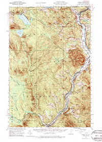
1953 Map of Averill
USGS Topo · Published 1987About this map
Canaan and Beecher Falls anchor the northern reaches of this New England borderland, where the Connecticut River serves as the dividing line between Vermont and New Hampshire. The landscape is defined by its industrial and logging heritage, marked by an extensive network of numbering logging camps like Camp No 16 and Camp No 3 scattered across the interior. Along the river corridor, the Maine Central and Grand Trunk River railroads trace the valley floor, connecting riverside settlements like Bloomfield and North Stratford. Local institutional history is visible in features such as the County Farm and Fish Hatchery near West Stewartstown. Significant peaks including Monadnock Mountain and Averill Mtn rise above the timbered tracts and glacial waters of Averill Lake and Wallace Pond, the latter of which straddles the international boundary with Canada.
Find a feature on this map
104 named features on this map. Tap any name to fly to it.
Don’t see what you’re looking for? This feature index may not catch every label — zoom into the map to look around manually.
Map Details
Editions of this 1953 Averill Map
5 editions found

Other maps of this area

1920 · Guildhall
USGS Topo · 1:62,500

1924 · Island Pond
USGS Topo · 1:48,000

1925 · Indian Stream
USGS Topo · 1:48,000

1926 · Island Pond
USGS Topo · 1:62,500

1926 · Indian Stream
USGS Topo · 1:62,500

1927 · Indian Stream
USGS Topo · 1:62,500

1929 · Averill
USGS Topo · 1:62,500

1930 · Percy
USGS Topo · 1:62,500

1930 · Dixville
USGS Topo · 1:62,500

1931 · Guildhall
USGS Topo · 1:48,000