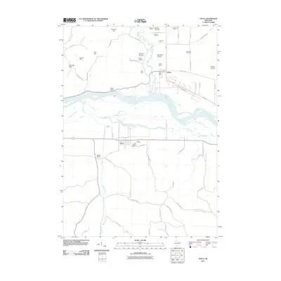
2010 Map of Avoca
USGS Topo · Published 2010About this map
The Wisconsin River serves as the central artery of this landscape, carving a wide valley between Bogus Bluff and the lowlands surrounding Avoca. The area's agricultural identity is exceptionally well-documented, with numerous named properties such as the Burr Oak Stock and Dairy Farm, Evergreen Farm, and Plainview Stock and Dairy Farm marking the transition from the river bottom to the northern hills. These specific farm labels offer a rare level of detail for turn-of-the-century family history and land-use research.
Find a feature on this map
64 named features on this map. Tap any name to fly to it.
Don’t see what you’re looking for? This feature index may not catch every label — zoom into the map to look around manually.
Map Details
Editions of this 2010 Avoca Map
This is the sole edition of this map. No revisions or reprints were ever made.
Other maps of this area

1905 · Richland Center
USGS Topo · 1:125,000

1958 · La Crosse
USGS Topo · 1:250,000

1960 · Richland Center
USGS Topo · 1:62,500

1960 · Plain
USGS Topo · 1:62,500

1960 · Muscoda
USGS Topo · 1:62,500

1960 · Spring Green
USGS Topo · 1:62,500

1961 · La Crosse
USGS Topo · 1:250,000

1965 · La Crosse
USGS Topo · 1:250,000

1976 · La Crosse
USGS Topo · 1:250,000
1983 · Highland West
USGS Topo · 1:24,000