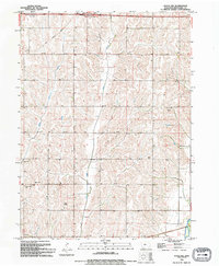
1994 Map of Avoca NW
USGS Topo · Published 1994About this map
Middle Silver Creek carves through a landscape of rolling hills and agricultural sections in this 1990s record of Pottawattamie County. The map captures the interface between rural traditions and modern infrastructure, notably where the Shelby Corp Bdy meets Interchange 34. For those researching local heritage, the southwestern portion of the sheet provides important markers of community life, including the Silver Creek Ch and the nearby Silver Valley Cem. In the southeastern corner, the topography descends toward the W Nishnabotna River, illustrating the drainage patterns that have historically defined Iowa farming. Utility and communications infrastructure are well-documented through landmarks like the Substa and the Radio Tower (KXKT), while a highway Rest Area serves travelers crossing the prairie landscape.
Find a feature on this map
11 named features on this map. Tap any name to fly to it.
Don’t see what you’re looking for? This feature index may not catch every label — zoom into the map to look around manually.
Map Details
Editions of this 1994 Avoca NW Map
This is the sole edition of this map. No revisions or reprints were ever made.
Other maps of this area

1954 · Omaha
USGS Topo · 1:250,000

1956 · Neola
USGS Topo · 1:24,000

1957 · Omaha
USGS Topo · 1:250,000

1957 · Taylor
USGS Topo · 1:24,000

1958 · Omaha
USGS Topo · 1:250,000

1963 · Avoca NW
USGS Topo · 1:24,000

1963 · Avoca SE
USGS Topo · 1:24,000

1963 · Oakland
USGS Topo · 1:24,000

1963 · Avoca
USGS Topo · 1:24,000

1978 · Corley
USGS Topo · 1:24,000