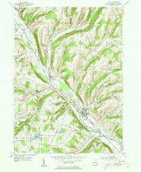
1953 Map of Avoca
USGS Topo · Published 1955About this map
The Cohocton River valley defines this mid-century landscape in Steuben County, where the parallel tracks of the Erie RR and the Delaware Lackawanna and Western RR trace the valley floor. The village of Avoca serves as a central hub for this transportation corridor, flanked by the smaller settlements of Wallace and Bloomerville to the northwest. This 1953 field-checked survey highlights a rural economy transitioning from early rail-dependent growth to a network of established farm roads like Loucks Road and Wagner Road.
Find a feature on this map
42 named features on this map. Tap any name to fly to it.
Don’t see what you’re looking for? This feature index may not catch every label — zoom into the map to look around manually.
Map Details
Editions of this 1953 Avoca Map
4 editions found
Other maps of this area

1900 · Naples
USGS Topo · 1:62,500

1902 · Wayland
USGS Topo · 1:62,500

1903 · Naples
USGS Topo · 1:62,500

1904 · Wayland
USGS Topo · 1:62,500

1910 · Bath
USGS Topo · 1:62,500

1913 · Naples
USGS Topo · 1:62,500

1915 · Hornell
USGS Topo · 1:62,500

1918 · Hornell
USGS Topo · 1:62,500

1942 · Wayland
USGS Topo · 1:31,680

1942 · Naples
USGS Topo · 1:31,680