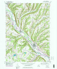
1953 Map of Avoca
USGS Topo · Published 1978About this map
The Cohocton River valley serves as the primary artery for transport and settlement in this portion of Steuben County, as seen through the 1950s and updated in the late 1970s. The village of Avoca sits at a strategic junction where the Erie Railroad and Bath and Hammondsport Railroad meet, reflecting the importance of rail transit to the local economy. Moving northwest along the river, the smaller hamlets of Wallace, Bloomerville, and Cohocton follow the natural topography created by the surrounding highlands, including Waterbury Hill and Canoe Hill.
Find a feature on this map
46 named features on this map. Tap any name to fly to it.
Don’t see what you’re looking for? This feature index may not catch every label — zoom into the map to look around manually.
Map Details
Editions of this 1953 Avoca Map
4 editions found
Other maps of this area

1900 · Naples
USGS Topo · 1:62,500

1902 · Wayland
USGS Topo · 1:62,500

1903 · Naples
USGS Topo · 1:62,500

1904 · Wayland
USGS Topo · 1:62,500

1910 · Bath
USGS Topo · 1:62,500

1913 · Naples
USGS Topo · 1:62,500

1915 · Hornell
USGS Topo · 1:62,500

1918 · Hornell
USGS Topo · 1:62,500

1942 · Wayland
USGS Topo · 1:31,680

1942 · Naples
USGS Topo · 1:31,680