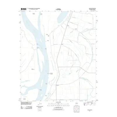
2011 Map of Avon
USGS Topo · Published 2011About this map
The Mississippi River dominates this landscape along the Washington County border, shaping a complex network of landings and riparian features during the early 21st century. The map documents numerous river access points including Seven Oaks Landing, Glenora Landing, and Stella Landing, reflecting the area's continued reliance on the waterway. Inland, the settlement of Avon and the nearby Graymound Cemetery provide specific focal points for local genealogy and history. A sophisticated drainage system, marked by features like Ditch Number Ten and Ditch Number Fourteen, supports the agricultural land protected by the prominent Levee Rd. The presence of the Mississippi Power and Light Company Lake Dam near Longwood illustrates the intersection of industrial utility and water management in this delta environment, where old river paths are preserved in names like Kentucky Bend and Cornfield Chute.
Find a feature on this map
49 named features on this map. Tap any name to fly to it.
Don’t see what you’re looking for? This feature index may not catch every label — zoom into the map to look around manually.
Map Details
Editions of this 2011 Avon Map
This is the sole edition of this map. No revisions or reprints were ever made.
Other maps of this area

1939 · Readland
USGS Topo · 1:62,500

1939 · Refuge
USGS Topo · 1:62,500

1939 · Tralake
USGS Topo · 1:62,500

1939 · Swan Lake
USGS Topo · 1:62,500

1953 · Greenwood
USGS Topo · 1:250,000

1956 · Greenwood
USGS Topo · 1:250,000

1967 · Arcola
USGS Topo · 1:24,000
1967 · Swan Lake NW
USGS Topo · 1:24,000
1967 · Percy
USGS Topo · 1:24,000
1969 · Swan Lake
USGS Topo · 1:62,500