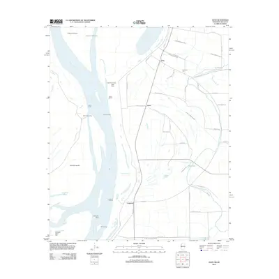
2012 Map of Avon
USGS Topo · Published 2012About this map
Mississippi River dynamics dominate this Washington County landscape, where the shifting channel has left behind complex terrain features like Kentucky Bend and Island Number 86. The riverfront is marked by a legacy of steamship commerce and agriculture, evidenced by several historic landing sites such as Eggs Point Landing, Auburn Landing, and Seven Oaks Landing. Inland, the alluvial plain is defined by the settlements of Avon, James, and Longwood, which are interconnected by a grid of rural roads and an extensive network of drainage infrastructure, including Ditch Number Nine A and Ditch Number Ten. Cultural sites such as Graymound Cem sit near natural water bodies like Goose Lake and Silver Lake, providing a detailed look at the rural Delta landscape before modern consolidation altered many of these small communities.
Find a feature on this map
56 named features on this map. Tap any name to fly to it.
Don’t see what you’re looking for? This feature index may not catch every label — zoom into the map to look around manually.
Map Details
Editions of this 2012 Avon Map
This is the sole edition of this map. No revisions or reprints were ever made.
Other maps of this area

1939 · Readland
USGS Topo · 1:62,500

1939 · Refuge
USGS Topo · 1:62,500

1939 · Tralake
USGS Topo · 1:62,500

1939 · Swan Lake
USGS Topo · 1:62,500

1953 · Greenwood
USGS Topo · 1:250,000

1956 · Greenwood
USGS Topo · 1:250,000

1967 · Arcola
USGS Topo · 1:24,000
1967 · Swan Lake NW
USGS Topo · 1:24,000
1967 · Percy
USGS Topo · 1:24,000
1969 · Swan Lake
USGS Topo · 1:62,500