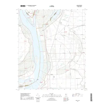
2018 Map of Avon
USGS Topo · Published 2018About this map
The Mississippi River defines the landscape of this delta region, carving a winding border between Washington County and Chicot County. Local communities such as Avon, Longwood, and James are positioned along the fertile alluvial plain, supported by a network of drainage infrastructure including Ditch Number Nine A and Ditch Number Ten. The complex hydrology is further marked by numerous oxbows and chutes, notably Goose Lake, Silver Lake, and Longwood Chute, which speak to the river's historical shifts and its continuing influence on land use.
Find a feature on this map
61 named features on this map. Tap any name to fly to it.
Don’t see what you’re looking for? This feature index may not catch every label — zoom into the map to look around manually.
Map Details
Editions of this 2018 Avon Map
This is the sole edition of this map. No revisions or reprints were ever made.
Other maps of this area

1939 · Readland
USGS Topo · 1:62,500

1939 · Refuge
USGS Topo · 1:62,500

1939 · Tralake
USGS Topo · 1:62,500

1939 · Swan Lake
USGS Topo · 1:62,500

1953 · Greenwood
USGS Topo · 1:250,000

1956 · Greenwood
USGS Topo · 1:250,000

1967 · Arcola
USGS Topo · 1:24,000
1967 · Swan Lake NW
USGS Topo · 1:24,000
1967 · Percy
USGS Topo · 1:24,000
1969 · Swan Lake
USGS Topo · 1:62,500