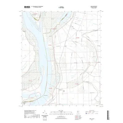
2020 Map of Avon
USGS Topo · Published 2020About this map
The Mississippi River carves a complex boundary between Washington County and Arkansas, defining a landscape of shifting channels and low-lying alluvial plains. This 2020 map documents the intricate network of drainage ditches, such as Ditch Number Nine A and Ditch Number Ten, that support the agricultural productivity of the Delta. The settlement of Avon sits near the junction of Avis Rd and Riverside Rd, while the Graymound Cem provides a point of genealogical interest nearby.
Find a feature on this map
59 named features on this map. Tap any name to fly to it.
Don’t see what you’re looking for? This feature index may not catch every label — zoom into the map to look around manually.
Map Details
Editions of this 2020 Avon Map
This is the sole edition of this map. No revisions or reprints were ever made.
Other maps of this area

1939 · Readland
USGS Topo · 1:62,500

1939 · Refuge
USGS Topo · 1:62,500

1939 · Tralake
USGS Topo · 1:62,500

1939 · Swan Lake
USGS Topo · 1:62,500

1953 · Greenwood
USGS Topo · 1:250,000

1956 · Greenwood
USGS Topo · 1:250,000

1967 · Arcola
USGS Topo · 1:24,000
1967 · Swan Lake NW
USGS Topo · 1:24,000
1967 · Percy
USGS Topo · 1:24,000
1969 · Swan Lake
USGS Topo · 1:62,500