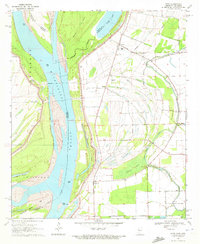
1970 Map of Avon
USGS Topo · Published 1972About this map
The Mississippi River dominates this 1970 landscape, winding through a complex borderland where Mississippi, Arkansas, and Louisiana converge. The terrain is defined by the shifting hydrology of the river, featuring large oxbow remnants like Lake Lee and Silver Lake, alongside active chutes such as Whiskey Chute and Cornfield Chute. These watercourses highlight a geography of seasonal change and engineering, marked by a prominent Levee system designed to manage the floodplain.
Find a feature on this map
40 named features on this map. Tap any name to fly to it.
Don’t see what you’re looking for? This feature index may not catch every label — zoom into the map to look around manually.
Map Details
Editions of this 1970 Avon Map
This is the sole edition of this map. No revisions or reprints were ever made.
Other maps of this area

1939 · Readland
USGS Topo · 1:62,500

1939 · Refuge
USGS Topo · 1:62,500

1939 · Tralake
USGS Topo · 1:62,500

1939 · Swan Lake
USGS Topo · 1:62,500

1953 · Greenwood
USGS Topo · 1:250,000

1956 · Greenwood
USGS Topo · 1:250,000

1967 · Arcola
USGS Topo · 1:24,000
1967 · Swan Lake NW
USGS Topo · 1:24,000
1967 · Percy
USGS Topo · 1:24,000
1969 · Swan Lake
USGS Topo · 1:62,500