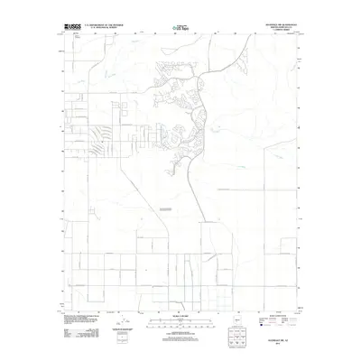
2011 Map of Avondale SW
USGS Topo · Published 2011About this map
Liberty Cemetery sits near the northern edge of this landscape, marking a legacy of early settlement just south of the Gila River. The terrain is defined by the braided drainage systems of Lum Wash and Corgett Wash, which cut across a mix of traditional agricultural grids and modern suburban development. While much of the western portion maintains a rigid section-line road network with names like S Tuthill Rd and S Rainbow Valley Rd, the eastern section shows the curving, planned streets of a growing residential community near S Estrella Pkwy. This juxtaposition illustrates the transition of the Arizona desert from rural farming and ranching roots to contemporary urbanization. Infrastructure supporting this growth is evident at the Rainbow Valley Water Reclamation Facility, while smaller residential arteries such as W San Gabriel Dr and S San Miguel Dr indicate the specific reach of early twenty-first-century housing expansion.
Find a feature on this map
62 named features on this map. Tap any name to fly to it.
Don’t see what you’re looking for? This feature index may not catch every label — zoom into the map to look around manually.
Map Details
Editions of this 2011 Avondale SW Map
This is the sole edition of this map. No revisions or reprints were ever made.
Other maps of this area

1946 · Avondale
USGS Topo · 1:62,500

1948 · Cashion
USGS Topo · 1:62,500

1951 · Mobile
USGS Topo · 1:62,500

1951 · Cotton Center
USGS Topo · 1:62,500

1954 · Phoenix
USGS Topo · 1:250,000

1957 · Phoenix
USGS Topo · 1:250,000

1957 · Valencia
USGS Topo · 1:24,000

1957 · Perryville
USGS Topo · 1:24,000

1957 · Tolleson
USGS Topo · 1:24,000

1957 · Avondale SW
USGS Topo · 1:24,000