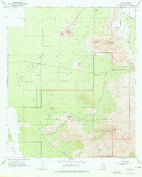
1968 Map of Avra
USGS Topo · Published 1976About this map
Saguaro National Monument anchors the landscape in this late 1960s survey, showing the protected desert terrain of the Tucson Mts as they overlook the Avra Valley. The map records a period of transition where traditional mining and ranching infrastructure coexists with emerging recreational and conservation uses. Scattered industrial sites like the Busterville Mine, Mile-Wide Mine, and a large Quarry near Twin Peaks contrast with established homesteads such as the M-Z Bar Ranch and Rancho de Esperanza. The network of trails, including the Hugh Norris Trail and King Canyon Trail, reveals how the area was becoming a destination for hikers and visitors, supported by the Red Hills Information Center and several dedicated picnic grounds like the Ez-Kim-In-Zin Picnic Area.
Find a feature on this map
40 named features on this map. Tap any name to fly to it.
Don’t see what you’re looking for? This feature index may not catch every label — zoom into the map to look around manually.
Map Details
Editions of this 1968 Avra Map
3 editions found
Other maps of this area

1925 · San Xavier
USGS Topo · 1:62,500

1934 · Tucson Mountains
USGS Topo · 1:125,000

1941 · Cocoraque Butte
USGS Topo · 1:62,500

1943 · Cocoraque Butte
USGS Topo · 1:62,500

1943 · San Xavier Mission
USGS Topo · 1:62,500

1947 · Cortaro
USGS Topo · 1:62,500

1956 · Tucson
USGS Topo · 1:250,000

1957 · San Xavier Mission
USGS Topo · 1:62,500

1957 · Cortaro
USGS Topo · 1:62,500

1958 · Tucson
USGS Topo · 1:250,000