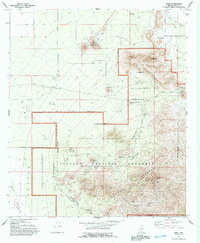
1968 Map of Avra
USGS Topo · Published 1993About this map
Saguaro National Monument dominates the eastern half of this landscape, where the peaks of the Tucson Mts rise sharply from the desert floor. The survey highlights the transition from the arid expanse of Avra Valley to the protected wilderness areas. Small-scale mining operations are scattered throughout the hills, including the Busterville Mine and Gould Mine, alongside the deeper industrial footprint of a large Quarry near Twin Peaks.
Find a feature on this map
37 named features on this map. Tap any name to fly to it.
Don’t see what you’re looking for? This feature index may not catch every label — zoom into the map to look around manually.
Map Details
Editions of this 1968 Avra Map
3 editions found
Other maps of this area

1925 · San Xavier
USGS Topo · 1:62,500

1934 · Tucson Mountains
USGS Topo · 1:125,000

1941 · Cocoraque Butte
USGS Topo · 1:62,500

1943 · Cocoraque Butte
USGS Topo · 1:62,500

1943 · San Xavier Mission
USGS Topo · 1:62,500

1947 · Cortaro
USGS Topo · 1:62,500

1956 · Tucson
USGS Topo · 1:250,000

1957 · San Xavier Mission
USGS Topo · 1:62,500

1957 · Cortaro
USGS Topo · 1:62,500

1958 · Tucson
USGS Topo · 1:250,000