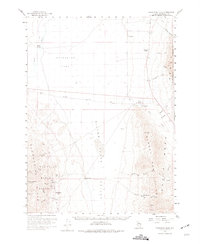
1958 Map of Awakening Peak
USGS Topo · Published 1975About this map
The Awakening Mining District defines this high-desert corridor of Humboldt County, where 1950s survey work captured a landscape of hard-rock extraction and cattle ranching. Centered on the Slumbering Hills, the map reveals a high density of mineral claims including the Humboldt Mine, Jumbo Mine, and Alabama Mine. Settlement here is sparse and strictly tied to water and wealth; the Awakening (Site) and Daveytown represent the human footprint in the shadow of Awakening Peak. To the east, the Bloody Run Hills rise from the Silver State Valley, punctuated by historic travel markers like Amos (Old Stage Station) and the Andorno Ranch. The Quinn River meanders through the western flats, providing a rare water source for River Ranch near the expansive Gallagher Flat.
Find a feature on this map
51 named features on this map. Tap any name to fly to it.
Don’t see what you’re looking for? This feature index may not catch every label — zoom into the map to look around manually.
Map Details
Editions of this 1958 Awakening Peak Map
2 editions found
Other maps of this area

1882 · Paradise
USGS Topo · 1:250,000

1886 · Disaster
USGS Topo · 1:250,000

1893 · Paradise
USGS Topo · 1:250,000

1893 · Disaster
USGS Topo · 1:250,000

1954 · Vya
USGS Topo · 1:250,000

1955 · McDermitt
USGS Topo · 1:250,000

1958 · Vya
USGS Topo · 1:250,000

1958 · Paradise Valley
USGS Topo · 1:62,500

1958 · Awakening Peak
USGS Topo · 1:62,500

1959 · McDermitt
USGS Topo · 1:250,000