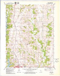
1979 Map of Axtell
USGS Topo · Published 1979About this map
The Middle Fork Salt River and its numerous tributaries, such as Duck Creek and Brush Creek, define the landscape of northern Macon County during the late 1970s. The city of Macon anchors the southern edge of the survey, where regional infrastructure like the Norfolk and Western railroad and local recreational sites including the Golf Course and Hillcrest Memorial Gardens are established. To the north, the creation of Long Branch Lake has altered the terrain, surrounded by the Atlanta State Wildlife Area. This era shows a transition from traditional rural patterns to modern water management and conservation. Small, established communities like Axtell and Kellogg are documented alongside numerous family and community burial grounds, such as Bellview Cem, Liberty Cem, and Powell Cem, which provide essential touchpoints for genealogical research and local history.
Find a feature on this map
37 named features on this map. Tap any name to fly to it.
Don’t see what you’re looking for? This feature index may not catch every label — zoom into the map to look around manually.
Map Details
Editions of this 1979 Axtell Map
This is the sole edition of this map. No revisions or reprints were ever made.
Other maps of this area

1908 · Atlanta
USGS Topo · 1:62,500

1908 · Macon
USGS Topo · 1:62,500

1910 · Macon
USGS Topo · 1:62,500

1937 · Elmer
USGS Topo · 1:48,000

1942 · Elmer
USGS Topo · 1:62,500

1953 · Moberly
USGS Topo · 1:250,000

1953 · Bevier South
USGS Topo · 1:24,000

1954 · Moberly
USGS Topo · 1:250,000

1957 · Moberly
USGS Topo · 1:250,000

1960 · Moberly
USGS Topo · 1:250,000