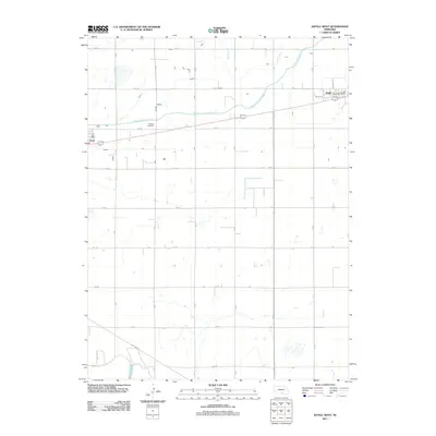
2011 Map of Axtell West
USGS Topo · Published 2011About this map
Fridhem Cemetery sits at the heart of this Nebraska agricultural landscape, serving as a significant landmark for genealogists researching the families of Kearney and Phelps counties. The map documents the western edge of Axtell and the settlement of Funk, both oriented along the east-west highway and rail corridor. The vital irrigation infrastructure of the region is prominently displayed, dominated by the Phelps County Canal which snakes across the northern half of the quadrangle. North-south section roads such as 20 RD and U RD impose a strict grid over the terrain, while the drainage of Dry Creek provides a natural contrast to the engineered waterways. Local centers of communication and commerce are noted by the presence of the Axtell Post Office and the Funk Post Office.
Find a feature on this map
35 named features on this map. Tap any name to fly to it.
Don’t see what you’re looking for? This feature index may not catch every label — zoom into the map to look around manually.
Map Details
Editions of this 2011 Axtell West Map
This is the sole edition of this map. No revisions or reprints were ever made.
Other maps of this area

1894 · Kearney
USGS Topo · 1:62,500

1896 · Holdrege
USGS Topo · 1:125,000

1896 · Kearney
USGS Topo · 1:125,000

1955 · Grand Island
USGS Topo · 1:250,000

1957 · Grand Island
USGS Topo · 1:250,000

1958 · Grand Island
USGS Topo · 1:250,000

1970 · Holdrege East
USGS Topo · 1:24,000

1970 · Axtell West
USGS Topo · 1:24,000
1970 · Kearney SE
USGS Topo · 1:24,000
1970 · Axtell East
USGS Topo · 1:24,000