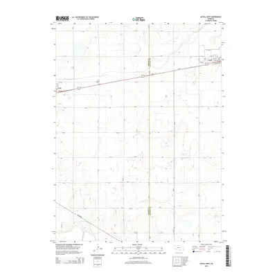
2014 Map of Axtell West
USGS Topo · Published 2014About this map
Agricultural patterns and transport corridors define this area along the Phelps Co and Kearney Co border. The settlement of Axtell anchors the northeastern corner, where a grid of residential streets like W 6th St and W 3rd St meets the transit lines of Us-34 and Ne-44. To the west, the village of Funk marks the opposite edge of this survey, connected by a long straight stretch of highway that runs parallel to the infrastructure of the Phelps County Canal. Between these two hubs, the landscape is meticulously organized into a mile-square grid of rural routes including 734 Rd and J Rd, occasionally interrupted by natural drainage features like Dry Cr. Local history is preserved at the Fridhem Cem, located just north of the highway, serving as a quiet landmark in the open plains.
Find a feature on this map
33 named features on this map. Tap any name to fly to it.
Don’t see what you’re looking for? This feature index may not catch every label — zoom into the map to look around manually.
Map Details
Editions of this 2014 Axtell West Map
This is the sole edition of this map. No revisions or reprints were ever made.
Other maps of this area

1894 · Kearney
USGS Topo · 1:62,500

1896 · Holdrege
USGS Topo · 1:125,000

1896 · Kearney
USGS Topo · 1:125,000

1955 · Grand Island
USGS Topo · 1:250,000

1957 · Grand Island
USGS Topo · 1:250,000

1958 · Grand Island
USGS Topo · 1:250,000

1970 · Holdrege East
USGS Topo · 1:24,000

1970 · Axtell West
USGS Topo · 1:24,000
1970 · Kearney SE
USGS Topo · 1:24,000
1970 · Axtell East
USGS Topo · 1:24,000