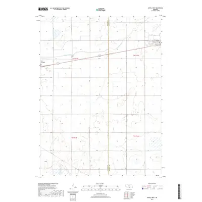
2017 Map of Axtell West
USGS Topo · Published 2017About this map
Agricultural lands along the Phelps Co Kearney Co line are defined by a strictly organized grid of rural roads and irrigation infrastructure. The village of Funk sits near the western edge of the sheet, while the western portion of Axtell occupies the northeastern corner. Linking these settlements is the Tri-County railroad corridor, which runs parallel to the primary east-west highway route. This 2017 survey highlights the area's dependence on water management, featuring the prominent Phelps County Canal and the natural drainage of Dry Cr. Genealogists and local historians will find the Fridhem Cem situated along 734 Rd, a central landmark in this rural landscape. The map's detail extends into the residential streets of Axtell, including W 6th St and F Ave, capturing the small-town layout of these Kearney County communities.
Find a feature on this map
41 named features on this map. Tap any name to fly to it.
Don’t see what you’re looking for? This feature index may not catch every label — zoom into the map to look around manually.
Map Details
Editions of this 2017 Axtell West Map
This is the sole edition of this map. No revisions or reprints were ever made.
Other maps of this area

1894 · Kearney
USGS Topo · 1:62,500

1896 · Holdrege
USGS Topo · 1:125,000

1896 · Kearney
USGS Topo · 1:125,000

1955 · Grand Island
USGS Topo · 1:250,000

1957 · Grand Island
USGS Topo · 1:250,000

1958 · Grand Island
USGS Topo · 1:250,000

1970 · Holdrege East
USGS Topo · 1:24,000

1970 · Axtell West
USGS Topo · 1:24,000
1970 · Kearney SE
USGS Topo · 1:24,000
1970 · Axtell East
USGS Topo · 1:24,000